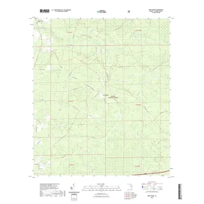
2021 Map of Deep Creek
USGS Topo · Published 2021About this map
Osceola National Forest dominates this northern Florida landscape, where a complex network of wetland basins and creek systems defines the terrain. The small community of Greenfield sits at a crossroads within the forest, served by Greenfield Tower Rd and Still Rd. To the northwest, the settlement of Deep Creek is positioned near the banks of Deep Cr. The area is characterized by numerous baygalls and wetlands with evocative local names such as Impassable Bay, Railroad Bay, and Sawgrass Head.
Find a feature on this map
49 named features on this map. Tap any name to fly to it.
Don’t see what you’re looking for? This feature index may not catch every label — zoom into the map to look around manually.
Map Details
Editions of this 2021 Deep Creek Map
This is the sole edition of this map. No revisions or reprints were ever made.
Other maps of this area

1954 · Valdosta
USGS Topo · 1:250,000

1958 · Valdosta
USGS Topo · 1:250,000

1959 · Valdosta
USGS Topo · 1:250,000

1961 · Deep Creek
USGS Topo · 1:24,000

1961 · White Springs East
USGS Topo · 1:24,000

1962 · Lake City East
USGS Topo · 1:24,000

1963 · Olustee
USGS Topo · 1:24,000

1963 · Lake City West
USGS Topo · 1:24,000

1969 · Sanderson NW
USGS Topo · 1:24,000
1969 · Benton
USGS Topo · 1:24,000