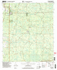
2005 Map of Deep Creek
USGS Topo · Published 2006About this map
Osceola National Forest dominates the landscape of this Columbia County survey, revealing a network of swamps, bays, and seasonal drainages. The settlement of Deep Creek and the site at Greenfield provide small anchors of human activity in an area defined by water and timber. The topographic detail shows how the terrain is shaped by numerous low-lying wetland basins, such as Otter Bay, Logging Bay, and Turtle Bay, which are connected by a system of small watercourses including Robinson Creek and Rolling Creek. Landmarks such as the West Tower Hunt Camp and a local Cem reflect the region's historical use for recreational hunting and family heritage. This edition captures the intricate hydrology of the Florida wetlands, with features like Church Pond and Sawgrass Pond illustrating the persistent presence of standing water throughout the forest interior.
Find a feature on this map
30 named features on this map. Tap any name to fly to it.
Don’t see what you’re looking for? This feature index may not catch every label — zoom into the map to look around manually.
Map Details
Editions of this 2005 Deep Creek Map
This is the sole edition of this map. No revisions or reprints were ever made.
Other maps of this area

1954 · Valdosta
USGS Topo · 1:250,000

1958 · Valdosta
USGS Topo · 1:250,000

1959 · Valdosta
USGS Topo · 1:250,000

1961 · Deep Creek
USGS Topo · 1:24,000

1961 · White Springs East
USGS Topo · 1:24,000

1962 · Lake City East
USGS Topo · 1:24,000

1963 · Olustee
USGS Topo · 1:24,000

1963 · Lake City West
USGS Topo · 1:24,000

1969 · Sanderson NW
USGS Topo · 1:24,000
1969 · Benton
USGS Topo · 1:24,000