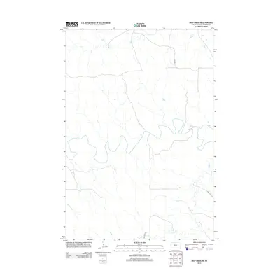
2012 Map of Deep Creek NE
USGS Topo · Published 2012About this map
The Moreau River meanders across this rural landscape in Perkins County, defining the drainage patterns of a region shaped by its watercourses. The river is joined by tributary systems including Rabbit Cr in the north and the multi-branched Deep Cr to the south. This terrain is sparsely populated, with the layout reflecting a vast grazing or agricultural district where movement is dictated by a few key corridors. Transport in the area is anchored by S Dakota Hwy 73, which cuts through the southeastern corner, while unpaved routes like Usta Rd and Deep Creek Rd provide the primary access to the interior sections of the quadrangle. The map captures the quiet character of the South Dakota plains, where the natural hydrology remains the most prominent feature of the land.
Find a feature on this map
6 named features on this map. Tap any name to fly to it.
Don’t see what you’re looking for? This feature index may not catch every label — zoom into the map to look around manually.
Map Details
Editions of this 2012 Deep Creek NE Map
This is the sole edition of this map. No revisions or reprints were ever made.
Other maps of this area

1951 · Deep Creek NW
USGS Topo · 1:24,000

1952 · Deep Creek SE
USGS Topo · 1:24,000

1952 · Signal Butte
USGS Topo · 1:24,000

1952 · Deep Creek NE
USGS Topo · 1:24,000

1952 · Faith NW
USGS Topo · 1:24,000

1954 · Lemmon
USGS Topo · 1:250,000

1957 · Lemmon
USGS Topo · 1:250,000

1983 · Sunrise Butte
USGS Topo · 1:24,000

1983 · Coal Springs SW
USGS Topo · 1:24,000
1983 · Two Buttes
USGS Topo · 1:24,000