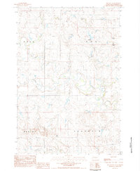
1983 Map of Two Buttes
USGS Topo · Published 1984About this map
Two Buttes and other prominent landmarks rise from the Perkins County landscape, serving as natural waypoints in this northern South Dakota territory. During the early 1980s, the region was defined by a complex network of seasonal drainage, including Rabbit Creek and its many tributaries such as Pickles Creek and North Reinoehl Creek. This map illustrates the transition from the Hall and Ada townships into the southern reaches of Brushy and Chaudoin. The terrain is marked by distinctive named heights like Flat Top Butte and Johnny Butte, which provide topographical relief in an area otherwise dominated by the winding paths of Antelope Creek and Smith Creek. These landforms and watercourses represent the foundational geography for local ranching and land management in the late twentieth century.
Find a feature on this map
15 named features on this map. Tap any name to fly to it.
Don’t see what you’re looking for? This feature index may not catch every label — zoom into the map to look around manually.
Map Details
Editions of this 1983 Two Buttes Map
This is the sole edition of this map. No revisions or reprints were ever made.
Other maps of this area

1951 · Deep Creek NW
USGS Topo · 1:24,000

1951 · Bixby
USGS Topo · 1:24,000

1952 · Deep Creek NE
USGS Topo · 1:24,000

1954 · Lemmon
USGS Topo · 1:250,000

1957 · Lemmon
USGS Topo · 1:250,000

1983 · Rabbit Butte
USGS Topo · 1:24,000

1983 · Sunrise Butte
USGS Topo · 1:24,000

1983 · Date NE
USGS Topo · 1:24,000

1983 · Owen Lake
USGS Topo · 1:24,000
1983 · Chance
USGS Topo · 1:24,000