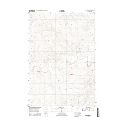
2015 Map of Deep Creek NE
USGS Topo · Published 2015About this map
The Moreau River meanders sharply through this Perkins County landscape, creating a series of dramatic oxbows and cutoffs as it flows eastward. This drainage system is the primary geographic driver for the region, supported by northern tributaries like Rabbit Cr and the namesake Deep Cr in the southern reaches. The terrain is defined by the Public Land Survey System, with boundaries for t15n r14e and t14n r15e clearly marking the transition between township blocks. While the land remains largely open ranching or agricultural ground, the presence of localized routes such as Usta Rd and 157th St provides access to the interior bluffs and river bottoms, tracing the practical paths used by local residents to navigate the river's winding course.
Find a feature on this map
10 named features on this map. Tap any name to fly to it.
Don’t see what you’re looking for? This feature index may not catch every label — zoom into the map to look around manually.
Map Details
Editions of this 2015 Deep Creek NE Map
This is the sole edition of this map. No revisions or reprints were ever made.
Other maps of this area

1951 · Deep Creek NW
USGS Topo · 1:24,000

1952 · Deep Creek SE
USGS Topo · 1:24,000

1952 · Signal Butte
USGS Topo · 1:24,000

1952 · Deep Creek NE
USGS Topo · 1:24,000

1952 · Faith NW
USGS Topo · 1:24,000

1954 · Lemmon
USGS Topo · 1:250,000

1957 · Lemmon
USGS Topo · 1:250,000

1983 · Sunrise Butte
USGS Topo · 1:24,000

1983 · Coal Springs SW
USGS Topo · 1:24,000
1983 · Two Buttes
USGS Topo · 1:24,000