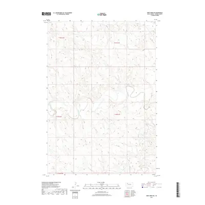
2017 Map of Deep Creek NE
USGS Topo · Published 2017About this map
The Moreau River carves a winding path through the center of this Perkins County landscape, which remains primarily defined by its drainage systems and section-line road network. The terrain is structured by several significant waterways, including Rabbit Creek in the north and Deep Creek to the south, reflecting the sparse, water-dependent geography of the West River region. Local transit is facilitated by rural routes such as Usta Road and County Road 8, which navigate the elevation changes between the river basin and the surrounding uplands. This area within the t14n r14e and t14n r15e township coordinates represents a typical section of the Great Plains, where the natural drainage of the river has dictated the placement of long-standing property lines and rural access points.
Find a feature on this map
10 named features on this map. Tap any name to fly to it.
Don’t see what you’re looking for? This feature index may not catch every label — zoom into the map to look around manually.
Map Details
Editions of this 2017 Deep Creek NE Map
This is the sole edition of this map. No revisions or reprints were ever made.
Other maps of this area

1951 · Deep Creek NW
USGS Topo · 1:24,000

1952 · Deep Creek SE
USGS Topo · 1:24,000

1952 · Signal Butte
USGS Topo · 1:24,000

1952 · Deep Creek NE
USGS Topo · 1:24,000

1952 · Faith NW
USGS Topo · 1:24,000

1954 · Lemmon
USGS Topo · 1:250,000

1957 · Lemmon
USGS Topo · 1:250,000

1983 · Sunrise Butte
USGS Topo · 1:24,000

1983 · Coal Springs SW
USGS Topo · 1:24,000
1983 · Two Buttes
USGS Topo · 1:24,000