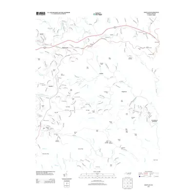
2013 Map of Deep Gap
USGS Topo · Published 2013About this map
S Fork New River and its tributary Pine Run carve through the high terrain of the Blue Ridge, anchoring a landscape of small settlements and mountain passes. The communities of Rutherwood, Laxon, and Bamboo are connected by a network of winding roads like Old US Hwy 421 S and Blue Ridge Pkwy. The map reveals a dense concentration of named gaps and knobs, including Days Gap, Deadman Gap, and Watson Gap, which historically dictated travel and settlement patterns throughout Watauga County. In the southern reach of the quadrangle, the terrain rises toward Sampson Mountain and High Peak, where numerous creeks such as Dugger Cr and Swift Ford Br drain the slopes. The inclusion of Grandview Overlook along the parkway highlights the region's transition into a destination for its far-reaching vistas, even as small pockets like Hogetown and Triplett maintain their local identity.
Find a feature on this map
237 named features on this map. Tap any name to fly to it.
Don’t see what you’re looking for? This feature index may not catch every label — zoom into the map to look around manually.
Map Details
Editions of this 2013 Deep Gap Map
This is the sole edition of this map. No revisions or reprints were ever made.
Other maps of this area

1889 · Wilkesboro
USGS Topo · 1:125,000

1891 · Wilkesboro
USGS Topo · 1:125,000

1893 · Cranberry
USGS Topo · 1:125,000

1895 · Cranberry
USGS Topo · 1:125,000

1899 · Cranberry
USGS Topo · 1:125,000

1902 · Cranberry
USGS Topo · 1:125,000

1934 · Boone
USGS Topo · 1:24,000

1935 · Zionville
USGS Topo · 1:24,000

1936 · Blowing Rock
USGS Topo · 1:48,000
1939 · Zionville
USGS Topo · 1:24,000