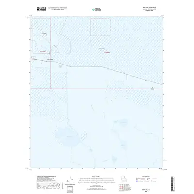
2020 Map of Deep Lake
USGS Topo · Published 2020About this map
Grand Chenier Ridge stands as a prominent elevation feature in this coastal wetland environment, carrying the path of La 82 through the marsh. The landscape is defined by an intricate network of waterways, including Southwest Bayou, Sardine Bayou, and the artificial North Island Canal, which feeds into the expanse of Deep Lake. Isolated high points like North Island, Money Island, and Tiger Island emerge from the surrounding wetlands, indicating the historical geography of this section of Cameron Parish. To the south and east, the transition from marsh to open water is marked by Grassy Lake and Blue Lake. The presence of Constance Ditch and Negro Ditch highlights the history of water management and drainage efforts in this low-lying territory during the late twentieth century.
Find a feature on this map
24 named features on this map. Tap any name to fly to it.
Don’t see what you’re looking for? This feature index may not catch every label — zoom into the map to look around manually.
Map Details
Editions of this 2020 Deep Lake Map
This is the sole edition of this map. No revisions or reprints were ever made.
Other maps of this area

1932 · Constance Bayou NE
USGS Topo · 1:31,680

1932 · Constance Bayou SW
USGS Topo · 1:31,680

1932 · Constance Bayou SE
USGS Topo · 1:31,680

1932 · Constance Bayou NW
USGS Topo · 1:31,680

1934 · Catfish Lake
USGS Topo · 1:24,000

1935 · Catfish Lake
USGS Topo · 1:31,680

1946 · Hog Bayou NE
USGS Topo · 1:31,680

1949 · Hog Bayou NE
USGS Topo · 1:31,680

1954 · Grand Lake East SE
USGS Topo · 1:31,680
1954 · Grand Lake East SW
USGS Topo · 1:31,680