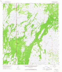
1959 Map of Deep Lake
USGS Topo · Published 1968About this map
Atlantic Coast Line tracks run north-south through this 1950s landscape, providing a narrow corridor of infrastructure through the Collier County wetlands. The settlement of Jerome anchors the southern portion of the sheet, while a Prison Camp is located further north near Deep Lake. The topography is defined by alternating strips of dense swamp forest and open grasslands, including the Fakahatchee Strand and Deep Lake Strand.
Find a feature on this map
14 named features on this map. Tap any name to fly to it.
Don’t see what you’re looking for? This feature index may not catch every label — zoom into the map to look around manually.
Map Details
Editions of this 1959 Deep Lake Map
3 editions found
Other maps of this area

1956 · Miami
USGS Topo · 1:250,000

1956 · West Palm Beach
USGS Topo · 1:250,000

1957 · West Palm Beach
USGS Topo · 1:250,000

1958 · West Palm Beach
USGS Topo · 1:250,000

1958 · Miami
USGS Topo · 1:250,000

1958 · Catherine Island
USGS Topo · 1:24,000

1959 · Miles City
USGS Topo · 1:24,000

1959 · Deep Lake
USGS Topo · 1:24,000

1959 · Deep Lake SW
USGS Topo · 1:24,000
1962 · Catherine Island
USGS Topo · 1:24,000