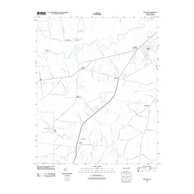
2010 Map of Deep Run
USGS Topo · Published 2010About this map
Deep Run is a focal point of this Lenoir County landscape, characterized by the winding path of the Neuse River and a dense network of named family roads and rural settlements. The area shows a transition from the river lowlands, marked by features like Pot Neck and Bucklesberry, to the higher agricultural ground where communities such as Sandy Bottom, Albrittons, and Moss Hill are situated. To the south, the industrial and community legacy of the region is evident at Tulls Mill and the adjacent Tull Millpond Dam, while the presence of the Deep Run Post Office anchors the namesake settlement. The map reveals a deeply rooted rural infrastructure, with numerous branches like Manley Branch and Turkey Branch feeding into larger water bodies, illustrating the drainage patterns that have historically dictated land use and settlement in this part of North Carolina.
Find a feature on this map
69 named features on this map. Tap any name to fly to it.
Don’t see what you’re looking for? This feature index may not catch every label — zoom into the map to look around manually.
Map Details
Editions of this 2010 Deep Run Map
This is the sole edition of this map. No revisions or reprints were ever made.
Other maps of this area

1914 · Kinston
USGS Topo · 1:48,000

1916 · Kinston
USGS Topo · 1:62,500

1953 · Rocky Mount
USGS Topo · 1:250,000

1954 · Rocky Mount
USGS Topo · 1:250,000

1957 · Goldsboro
USGS Topo · 1:62,500

1957 · Seven Springs
USGS Topo · 1:62,500

1958 · Deep Run
USGS Topo · 1:62,500

1980 · Seven Springs
USGS Topo · 1:24,000
1980 · Pink Hill
USGS Topo · 1:24,000
1980 · Deep Run
USGS Topo · 1:24,000