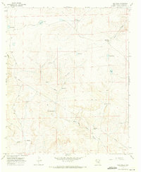
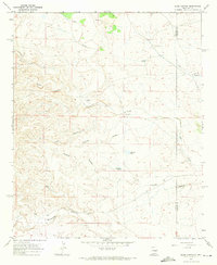
1967 Map of Deep Well
USGS Topo · Published 1971About this map
Water management dominates this arid New Mexico landscape, where a sophisticated network of tanks, wells, and pipelines supported ranching operations during the late 1960s. Deep Well and the Shearing Shed Well indicate the functional infrastructure required for livestock in Chaves County, while family-named landmarks like Will Johnson Tank, Joes Tank, and Bill Parks Tank suggest the long-term human presence in this region. The terrain is defined by natural drainage systems including China Draw and Rosy Draw, which feed into various catchment areas like South Lake and Browns Lake. The survey also documents modern utility development, notably a Pipeline that cuts through the southwestern area near Pipeline Tank, illustrating the technological layering of resources and transit across the High Plains landscape.
Find a feature on this map
24 named features on this map. Tap any name to fly to it.
Don’t see what you’re looking for? This feature index may not catch every label — zoom into the map to look around manually.
Map Details
Editions of this 1967 Deep Well Map
2 editions found
Other maps of this area

1955 · Roswell
USGS Topo · 1:250,000

1958 · Roswell
USGS Topo · 1:250,000

1962 · Roswell
USGS Topo · 1:250,000

1962 · Rock House Canyon
USGS Topo · 1:24,000
1963 · Barn Draw
USGS Topo · 1:24,000

1967 · Round Mountain SE
USGS Topo · 1:24,000

1967 · North Lake
USGS Topo · 1:24,000

1967 · White Flat
USGS Topo · 1:24,000
1967 · White Flat SE
USGS Topo · 1:24,000
1967 · Elsie Canyon
USGS Topo · 1:24,000