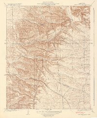
1931 Map of Deepwell Ranch
USGS Topo · Published 1931About this map
Deepwell Ranch and the surrounding foothills of Kern County are depicted here just before the 1930s. The landscape is defined by the seasonal drainage of Dyer Creek, which cuts through the undulating terrain near several established homesteads including Hodgeman Ranch and the small settlement at Villards. This 1928 survey by C.A. Stonesifer and O.L. Wix highlights the early infrastructure of the region, showing the primary artery of the Mc Farland Woody Road as it winds through the hills. A notable industrial feature is the prominent Transmission Line cutting across the central quadrangle, signaling the expansion of the utility grid into the rural interior of California. The map serves as a detailed record of land use and property boundaries in this transition zone between the Central Valley and the Sierra Nevada foothills.
Find a feature on this map
7 named features on this map. Tap any name to fly to it.
Don’t see what you’re looking for? This feature index may not catch every label — zoom into the map to look around manually.
Map Details
Editions of this 1931 Deepwell Ranch Map
3 editions found
Other maps of this area

1906 · Bakersfield
USGS Topo · 1:62,500

1926 · Quincy School
USGS Topo · 1:31,680

1927 · McFarland
USGS Topo · 1:31,680

1929 · Delano
USGS Topo · 1:31,680

1929 · Richgrove
USGS Topo · 1:31,680

1929 · Quincy School
USGS Topo · 1:31,680

1930 · McFarland
USGS Topo · 1:31,680

1930 · Famoso
USGS Topo · 1:31,680

1931 · Deepwell Ranch
USGS Topo · 1:31,680

1932 · North of Oildale
USGS Topo · 1:31,680