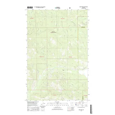
2017 Map of Deer Creek
USGS Topo · Published 2017About this map
Pleasant Valley serves as the central focal point of this Northwest Montana landscape, where the Pleasant Valley Fisher River winds through a valley floor bordered by the high timber of the Kootenai National Forest. This 2017 survey details the complex network of drainage systems that feed the river, including Tamarack Cr, Tensaw Cr, and Deer Cr. The boundary between Lincoln and Flathead counties cuts across the northeastern corner of the map, illustrating how administrative lines intersect with the physical topography. A network of secondary transportation routes, such as Pleasant Valley Rd and Natl Forest Develop Road 2349 Rd, provide the primary access to this remote region, tracing the contours of the land through several townships and ranges.
Find a feature on this map
17 named features on this map. Tap any name to fly to it.
Don’t see what you’re looking for? This feature index may not catch every label — zoom into the map to look around manually.
Map Details
Editions of this 2017 Deer Creek Map
This is the sole edition of this map. No revisions or reprints were ever made.
Other maps of this area

1920 · Jennings
USGS Topo · 1:125,000

1935 · Thompson Lakes
USGS Topo · 1:96,000

1942 · Thompson Lakes
USGS Topo · 1:125,000

1957 · Kalispell
USGS Topo · 1:250,000

1960 · Kalispell
USGS Topo · 1:250,000

1961 · Kalispell
USGS Topo · 1:250,000

1963 · Wolf Prairie
USGS Topo · 1:24,000
1963 · Horse Hill
USGS Topo · 1:24,000
1963 · Richards Mountain
USGS Topo · 1:24,000

1964 · Meadow Peak
USGS Topo · 1:24,000