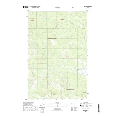
2020 Map of Deer Creek
USGS Topo · Published 2020About this map
Pleasant Valley occupies the southeastern reaches of this terrain, where the Pleasant Valley Fisher River meanders through the landscape near the Lincoln and Flathead County line. The area is defined by the dense drainage networks of the Kootenai National Forest, including the headwaters of Tamarack Cr, Calx Cr, and Deer Cr. A complex system of logging and access routes, such as Natl Forest Develop Road 2346 Rd and Natl For Dev Road 2348 Rd, crisscross the high elevations between Tensaw Cr and the river valley. The map documents the interface of mountainous timberland and the more open valley floor, illustrating how modern forest management roads follow the natural contours of the northern Rockies.
Find a feature on this map
18 named features on this map. Tap any name to fly to it.
Don’t see what you’re looking for? This feature index may not catch every label — zoom into the map to look around manually.
Map Details
Editions of this 2020 Deer Creek Map
This is the sole edition of this map. No revisions or reprints were ever made.
Other maps of this area

1920 · Jennings
USGS Topo · 1:125,000

1935 · Thompson Lakes
USGS Topo · 1:96,000

1942 · Thompson Lakes
USGS Topo · 1:125,000

1957 · Kalispell
USGS Topo · 1:250,000

1960 · Kalispell
USGS Topo · 1:250,000

1961 · Kalispell
USGS Topo · 1:250,000

1963 · Wolf Prairie
USGS Topo · 1:24,000
1963 · Horse Hill
USGS Topo · 1:24,000
1963 · Richards Mountain
USGS Topo · 1:24,000

1964 · Meadow Peak
USGS Topo · 1:24,000