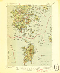
1944 Map of Deer Isle
USGS Topo · Published 1944About this map
Stonington serves as the industrial and maritime hub of this mid-century coastal survey, reflecting a landscape defined by granite extraction and seafaring. Multiple Quarries dot the southern tip of the island, highlighting the era's significant stone industry that shaped the local economy. Beyond the main village, smaller settlements like Mountainville, Oceanville, and Sunshine are linked by a network of early roads, including State Route 15.
Find a feature on this map
79 named features on this map. Tap any name to fly to it.
Don’t see what you’re looking for? This feature index may not catch every label — zoom into the map to look around manually.
Map Details
Editions of this 1944 Deer Isle Map
2 editions found

Other maps of this area

1902 · Castine
USGS Topo · 1:62,500

1904 · Deer Isle
USGS Topo · 1:62,500

1904 · Castine
USGS Topo · 1:62,500

1904 · Mount Desert
USGS Topo · 1:62,500

1904 · Swan Island
USGS Topo · 1:62,500

1904 · Bluehill
USGS Topo · 1:62,500

1904 · Vinalhaven
USGS Topo · 1:62,500

1905 · Penobscot Bay
USGS Topo · 1:125,000

1906 · Matinicus
USGS Topo · 1:62,500

1941 · Castine
USGS Topo · 1:62,500