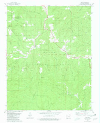
1980 Map of Deer
USGS Topo · Published 1981About this map
Ozark National Forest covers much of this high-elevation terrain in Newton County, where small mountain communities like Deer and Cowell are situated along the ridgelines. The landscape is defined by deep incisions from the Little Buffalo River and numerous drainage hollows such as Sandy Springs Hollow and Lonesome Hollow. Settlement patterns follow the high ground, with religious and community life centered at Stone Mtn Ch, Deer Ch, and the Deer Cem.
Find a feature on this map
45 named features on this map. Tap any name to fly to it.
Don’t see what you’re looking for? This feature index may not catch every label — zoom into the map to look around manually.
Map Details
Editions of this 1980 Deer Map
2 editions found
Other maps of this area

1889 · Treat
USGS Topo · 1:62,500

1889 · Ozone
USGS Topo · 1:62,500

1932 · Treat
USGS Topo · 1:62,500

1933 · Mt Judea
USGS Topo · 1:62,500

1934 · Treat
USGS Topo · 1:62,500

1934 · Ozone
USGS Topo · 1:62,500

1936 · Ozone
USGS Topo · 1:62,500

1940 · Mt Judea
USGS Topo · 1:62,500

1956 · Russellville
USGS Topo · 1:250,000

1964 · Russellville
USGS Topo · 1:250,000