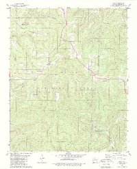
1980 Map of Deer
USGS Topo · Published 1989About this map
Deer and Cowell serve as the primary hubs of this upland region within the Ozark National Forest during the late 1970s. The landscape is defined by its drainage into the Little Buffalo River and its numerous named branches, including Dog Branch and West Fork Shop Creek. High ridges such as Henderson Mountain and Parker Ridge dictate the layout of small settlements and isolated landmarks. The map documents several important community sites for local history, notably the Deer Ch, Stone Mtn Ch, and the Deer Cem. Natural landmarks are also prominent, including the Alum Cove Natural Bridge Recreation Area and the Natural Bridge itself, alongside geographic markers like Norton Gap and Millsaps Knob.
Find a feature on this map
41 named features on this map. Tap any name to fly to it.
Don’t see what you’re looking for? This feature index may not catch every label — zoom into the map to look around manually.
Map Details
Editions of this 1980 Deer Map
2 editions found
Other maps of this area

1889 · Treat
USGS Topo · 1:62,500

1889 · Ozone
USGS Topo · 1:62,500

1932 · Treat
USGS Topo · 1:62,500

1933 · Mt Judea
USGS Topo · 1:62,500

1934 · Treat
USGS Topo · 1:62,500

1934 · Ozone
USGS Topo · 1:62,500

1936 · Ozone
USGS Topo · 1:62,500

1940 · Mt Judea
USGS Topo · 1:62,500

1956 · Russellville
USGS Topo · 1:250,000

1964 · Russellville
USGS Topo · 1:250,000