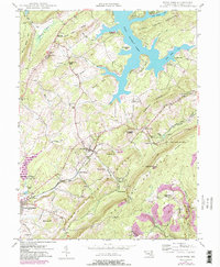
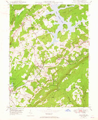
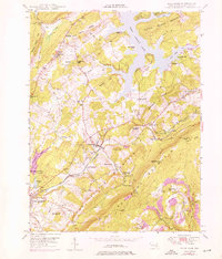
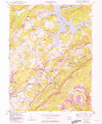
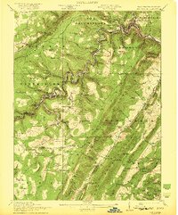
1948 Map of Deer Park
USGS Topo · Published 1982About this map
The Baltimore and Ohio railroad corridor anchors the human geography of this Western Maryland landscape, threading through the high-elevation settlements of Mountain Lake Park, Loch Lynn Heights, and Deer Park. These communities are situated along the Little Youghiogheny River and Broad Ford Run, the latter featuring the Broadford Dam and Mountain Lake. The map illustrates a transition from the industrial and transport-heavy valley to the recreational shoreline of Deep Creek Lake, where a Boy Scout Camp and Holy Cross Camp are located near Turkey Neck. Evidence of local rural life is visible in the network of schools and churches, such as Spring Glade Sch and the Sand Flat Tabernacle. The terrain is defined by prominent ridges including Backbone Mountain and Little Snaggy Mountain, with purple revisions from 1979 documenting the growth of residential enclaves like Truesdell Heights.
Find a feature on this map
68 named features on this map. Tap any name to fly to it.
Don’t see what you’re looking for? This feature index may not catch every label — zoom into the map to look around manually.
Map Details
Editions of this 1948 Deer Park Map
4 editions found
Other maps of this area

1895 · Piedmont
USGS Topo · 1:125,000

1899 · Grantsville
USGS Topo · 1:62,500

1899 · Oakland
USGS Topo · 1:62,500

1900 · Accident
USGS Topo · 1:62,500

1900 · Oakland
USGS Topo · 1:62,500

1904 · Grantsville
USGS Topo · 1:62,500

1919 · Elk Garden
USGS Topo · 1:48,000

1920 · Elk Garden
USGS Topo · 1:48,000
1922 · Elk Garden
USGS Topo · 1:62,500
1947 · Sang Run
USGS Topo · 1:24,000