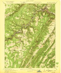
1922 Map of Elk Garden
USGS Topo · Published 1922About this map
The Potomac River carves a deep, winding path through this 1922 study, serving as the critical boundary between Maryland and West Virginia. Along its banks, the industrial character of the era is evident in the cluster of rail-oriented settlements like Westernport, Piedmont, and Bloomington, where the Baltimore and Ohio railroad threads through the narrow river valley. Further south, the map documents a network of highland coal towns and timber communities including Elk Garden, Vindex, and Kitzmiller. The landscape is dotted with small-scale rural infrastructure, from the Nethken School and Sharpless School to the Rehoboth Church, illustrating the scattered but organized social structure of the Potomac Highlands during the early twentieth century. These small settlements and schools provide a detailed view of the region's topography before modern development altered the local road and rail networks.
Find a feature on this map
102 named features on this map. Tap any name to fly to it.
Don’t see what you’re looking for? This feature index may not catch every label — zoom into the map to look around manually.
Map Details
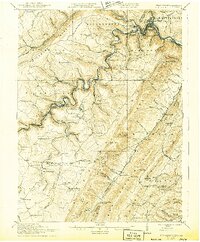
Editions of this 1922 Elk Garden Map
2 editions found
Other maps of this area

1891 · Romney
USGS Topo · 1:125,000

1895 · Piedmont
USGS Topo · 1:125,000

1898 · Frostburg
USGS Topo · 1:62,500

1899 · Grantsville
USGS Topo · 1:62,500

1899 · Oakland
USGS Topo · 1:62,500

1900 · Accident
USGS Topo · 1:62,500

1900 · Oakland
USGS Topo · 1:62,500

1901 · Frostburg
USGS Topo · 1:62,500

1904 · Grantsville
USGS Topo · 1:62,500

1908 · Frostburg
USGS Topo · 1:62,500