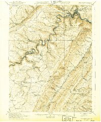
1922 Map of Elk Garden
USGS Topo · Published 1943About this map
Potomac River gorge-lands define this 1922 survey, illustrating the industrial and agricultural landscape spanning the West Virginia and Maryland border. The serpentine river serves as a corridor for the Baltimore and Ohio Railroad, connecting coal-associated settlements such as Piedmont, Kitzmiller, and Elk Garden. The high elevations of Backbone Mountain and New Creek Mountain are dotted with isolated community landmarks like the Mt. Zion Church and Rehoboth Church, alongside numerous small schoolhouses like Terra Firma School and Empire School. A notable concentration of activity appears at the W. Va. Central Junc., where the rail network branches out to serve the steep-walled valleys. The presence of Dodson P.O. and other rural hamlets like Hartmansville and Laurel Dale indicates a decentralized but persistent settlement pattern typical of the era's mining and timber-driven economy.
Find a feature on this map
109 named features on this map. Tap any name to fly to it.
Don’t see what you’re looking for? This feature index may not catch every label — zoom into the map to look around manually.
Map Details
Editions of this 1922 Elk Garden Map
2 editions found

Other maps of this area

1891 · Romney
USGS Topo · 1:125,000

1895 · Piedmont
USGS Topo · 1:125,000

1898 · Frostburg
USGS Topo · 1:62,500

1899 · Grantsville
USGS Topo · 1:62,500

1899 · Oakland
USGS Topo · 1:62,500

1900 · Accident
USGS Topo · 1:62,500

1900 · Oakland
USGS Topo · 1:62,500

1901 · Frostburg
USGS Topo · 1:62,500

1904 · Grantsville
USGS Topo · 1:62,500

1908 · Frostburg
USGS Topo · 1:62,500