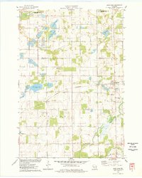
1975 Map of Deer Park
USGS Topo · Published 1978About this map
Deer Park serves as a primary hub of activity in this northern St. Croix County landscape during the mid-1970s. The village is positioned along the Chicago and North Western railroad line, while the southern portion of the map is traversed by the Soo Line. The region is defined by its glacial hydrology, featuring numerous lakes and wetlands including Oak Ridge Lake, North Fish Lake, and the winding Willow River.
Find a feature on this map
27 named features on this map. Tap any name to fly to it.
Don’t see what you’re looking for? This feature index may not catch every label — zoom into the map to look around manually.
Map Details
Editions of this 1975 Deer Park Map
This is the sole edition of this map. No revisions or reprints were ever made.
Other maps of this area

1900 · St Croix Dalles
USGS Topo · 1:62,500

1901 · St Croix Dalles
USGS Topo · 1:62,500

1948 · New Richmond
USGS Topo · 1:62,500

1949 · New Richmond
USGS Topo · 1:62,500

1950 · Deer Park
USGS Topo · 1:62,500

1950 · Balsam Lake
USGS Topo · 1:62,500

1953 · Stillwater
USGS Topo · 1:250,000

1955 · St. Croix Dalles
USGS Topo · 1:62,500

1955 · Stillwater
USGS Topo · 1:250,000

1958 · Stillwater
USGS Topo · 1:250,000