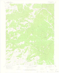
1963 Map of Deer Peak
USGS Topo · Published 1975About this map
San Isabel National Forest dominates this high-altitude landscape of the Sangre de Cristo Mountains, where the drainage divide between Hardscrabble Creek and Williams Creek shapes the geography. The map captures a mid-century wilderness where high-country parks like Junkins Park and Antelope Park provided open ground amidst dense timber and steep drainages such as Deadman Gulch and Treasure Gulch. Evidence of human activity is sparse but specific, including a radio tower atop the 11,572-foot summit of Deer Peak and the remote Abbey Summer Camp to the east. The terrain is marked by family-named landmarks like Piltz Mtn and Wixson Mountain, alongside various Mines that point to the region's prospecting history. A network of primitive routes, including the Gardner Road and several Jeep Trails, provides the only access into these high valleys and canyons.
Find a feature on this map
46 named features on this map. Tap any name to fly to it.
Don’t see what you’re looking for? This feature index may not catch every label — zoom into the map to look around manually.
Map Details
Editions of this 1963 Deer Peak Map
3 editions found
Other maps of this area

1889 · Canon City
USGS Topo · 1:125,000

1889 · Huerfano Park
USGS Topo · 1:125,000

1892 · Huerfano Park
USGS Topo · 1:125,000

1892 · Canon City
USGS Topo · 1:125,000

1954 · Mount Tyndall
USGS Topo · 1:24,000

1954 · Rosita
USGS Topo · 1:24,000

1954 · Trinidad
USGS Topo · 1:250,000

1954 · Pueblo
USGS Topo · 1:250,000

1955 · Trinidad
USGS Topo · 1:250,000

1957 · Pueblo
USGS Topo · 1:250,000