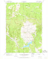
1956 Map of Deerfield
USGS Topo · Published 1968About this map
Deerfield Lake serves as a central hub for the drainage and geography of this section of the Black Hills National Forest. In the mid-1950s, the landscape was a mix of resource extraction and scattered high-country ranching. Gold mining efforts are marked by the Yellow Bird Mine, King of the West Mine, and Black Tunnel Mine near Castle Creek. Small local schools like the Deerfield Sch and Reynolds Prairie Sch provide evidence of the rural community's footprint during this era. High peaks such as Flag Mountain, complete with its Lookout Tower, and White Tail Peak dominate the skyline above a network of draws and gulches. The area's settlement pattern is defined by family-named holdings, including the Monheim Ranch and Erickson Ranch, alongside recreational spots like Merry-Go-Round Camp.
Find a feature on this map
59 named features on this map. Tap any name to fly to it.
Don’t see what you’re looking for? This feature index may not catch every label — zoom into the map to look around manually.
Map Details
Editions of this 1956 Deerfield Map
4 editions found
Other maps of this area

1894 · Deadwood
USGS Topo · 1:125,000

1896 · Harney Peak
USGS Topo · 1:125,000

1901 · Harney Peak
USGS Topo · 1:125,000

1901 · Deadwood
USGS Topo · 1:125,000

1916 · Deadwood
USGS Topo · 1:125,000

1953 · Rapid City
USGS Topo · 1:250,000

1955 · Hot Springs
USGS Topo · 1:250,000
1956 · Custer
USGS Topo · 1:62,500
1956 · Crooks Tower
USGS Topo · 1:24,000
1956 · Crows Nest Peak
USGS Topo · 1:24,000