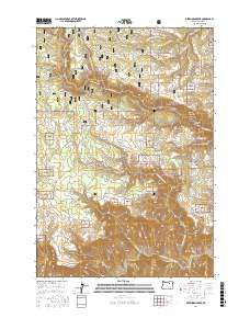
2017 Map of Deerhorn Creek
USGS Topo · Published 2017About this map
Gilman Ranch anchors the northwest corner of this drainage basin, overlooking a landscape defined by the deep incisions of the North Fork John Day River and its numerous tributaries. Situated within the Umatilla National Forest, the terrain rises from the river canyon at Bone Canyon to the prominent heights of Sugarbowl Ridge and Deerhorn Ridge. The map details a complex network of forest development roads, such as Nat For Dev Rd 140, that provide access to high-plateau features like Buckaroo Flat. This 2017 survey reflects the modern management of this watershed, tracing the paths of Deerhorn Creek and Fivemile Cr through protected timberlands. Smaller landmarks, including Box Spring and the curiously named Stinking Water Pond, offer specific points of interest for those studying the hydrology and local nomenclature of this part of Umatilla County.
Find a feature on this map
45 named features on this map. Tap any name to fly to it.
Don’t see what you’re looking for? This feature index may not catch every label — zoom into the map to look around manually.
Map Details
Editions of this 2017 Deerhorn Creek Map
This is the sole edition of this map. No revisions or reprints were ever made.
Other maps of this area

1950 · Ritter
USGS Topo · 1:62,500

1951 · Dale
USGS Topo · 1:62,500

1952 · Ritter
USGS Topo · 1:62,500

1953 · Pendleton
USGS Topo · 1:250,000

1955 · Canyon City
USGS Topo · 1:250,000

1956 · Pendleton
USGS Topo · 1:250,000

1959 · Canyon City
USGS Topo · 1:250,000

1967 · Bridge Creek
USGS Topo · 1:24,000

1967 · Ukiah
USGS Topo · 1:24,000

1969 · Sugarbowl Creek
USGS Topo · 1:24,000