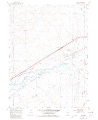
1967 Map of Deeth
USGS Topo · Published 1980About this map
Humboldt River and Marys River converge near the rail settlement of Deeth, where the regional transport infrastructure of the late 1960s is clearly defined. This desert landscape is shaped by the parallel paths of the Southern Pacific and Western Pacific railroads, which track the river valley through Dennis Flats. The map reveals a transition from these industrial transit corridors to the agricultural and ranching expanses of Starr Valley, where several family-named watercourses like Starr Creek, Stephens Creek, and Ackler Cr drain toward the basin. Pockets of activity are noted at the Deeth Interchange and a nearby Landing Field, while the presence of the Radio Tower and various wells like Marble Well and Sagebrush Well indicate the management of this arid Elko County terrain.
Find a feature on this map
30 named features on this map. Tap any name to fly to it.
Don’t see what you’re looking for? This feature index may not catch every label — zoom into the map to look around manually.
Map Details
Editions of this 1967 Deeth Map
2 editions found
Other maps of this area

1935 · Halleck
USGS Topo · 1:125,000

1955 · Wells
USGS Topo · 1:250,000

1955 · Elko
USGS Topo · 1:250,000

1958 · Wells
USGS Topo · 1:250,000

1958 · Elko
USGS Topo · 1:250,000

1961 · Wells
USGS Topo · 1:250,000

1962 · Elko
USGS Topo · 1:250,000

1965 · Elko
USGS Topo · 1:250,000

1967 · Twin Buttes
USGS Topo · 1:24,000

1967 · Peko Peak
USGS Topo · 1:24,000