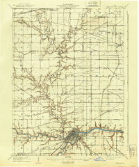
1909 Map of Defiance
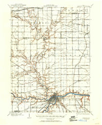
USGS Topo · Published 1940About this map
The confluence of the Maumee River and the Auglaize River anchors this 1906–1907 survey of Northwest Ohio, where the industrial and transport hub of Defiance sits at the water's edge. The map captures a critical transition in American infrastructure, documenting the surviving path of the Miami and Erie Canal alongside a dense network of competing rail lines, including the Wabash RR and the interurban Toledo and Indiana Electric Ry. North of the river, the landscape is defined by the winding course of the Tiffin River, which passes near the settlement of Evansport. Smaller communities like Ridgeville Corners and Jewell are depicted during a period of agricultural growth, linked by early roads that follow the section lines across Fulton and Defiance counties.
Find a feature on this map
53 named features on this map. Tap any name to fly to it.
Don’t see what you’re looking for? This feature index may not catch every label — zoom into the map to look around manually.
Map Details
Editions of this 1909 Defiance Map
This is the sole edition of this map. No revisions or reprints were ever made.
Historical Maps of Defiance Through Time
3 maps found

Featured Locations
- Defiance, OH
- Archbold, OH
- Hickory Hills, Springfield Township
- Promised Land Subdivision, Springfield Township
- Stryker, Springfield Township