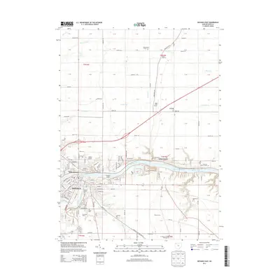
2013 Map of Defiance East
USGS Topo · Published 2013About this map
The confluence of the Auglaize River and the Maumee River defines the landscape of this 2013 survey, where the city of Defiance serves as the regional hub. The map captures the urban footprint of the city, including institutional landmarks like Defiance College and athletic sites such as Justin F Coressel Stadium and Fred Brown Stadium. Extending eastward from the city center, the Maumee River flows toward the Independence Reservoir, passing Preston Island and the small settlement of Independence. A network of rural roads, including Adams Ridge Road and Jewell Road, connects outlying areas like Jewell to the river corridor. The map is particularly useful for genealogical research, documenting numerous burial sites across the countryside, from the Saint Michaels Catholic Cemetery in the north to the Pleasant Bend and Ayersville Cemetery in the south.
Find a feature on this map
90 named features on this map. Tap any name to fly to it.
Don’t see what you’re looking for? This feature index may not catch every label — zoom into the map to look around manually.
Map Details
Editions of this 2013 Defiance East Map
This is the sole edition of this map. No revisions or reprints were ever made.
Other maps of this area

1907 · Defiance
USGS Topo · 1:62,500

1908 · Ottawa
USGS Topo · 1:62,500

1908 · Napoleon
USGS Topo · 1:62,500

1909 · Defiance
USGS Topo · 1:62,500

1909 · Continental
USGS Topo · 1:62,500

1953 · Fort Wayne
USGS Topo · 1:250,000

1956 · Fort Wayne
USGS Topo · 1:250,000

1959 · Defiance East
USGS Topo · 1:24,000
1959 · Ridgeville Corners
USGS Topo · 1:24,000

1959 · Florida
USGS Topo · 1:24,000