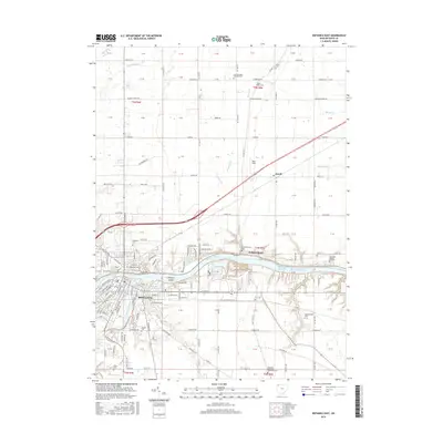
2016 Map of Defiance East
USGS Topo · Published 2016About this map
The confluence of the Maumee River and the Auglaize River serves as the focal point for Defiance, Ohio, a city deeply shaped by its waterways and regional transportation networks. This 2016 survey highlights the eastern expansion of the city, including the campus of Defiance Coll, while tracing the rural landscape of Defiance County. Downriver, the Independence Reservoir and the small settlement of Independence illustrate the managed nature of the Maumee, which is punctuated by landmarks like Preston Island.
Find a feature on this map
120 named features on this map. Tap any name to fly to it.
Don’t see what you’re looking for? This feature index may not catch every label — zoom into the map to look around manually.
Map Details
Editions of this 2016 Defiance East Map
This is the sole edition of this map. No revisions or reprints were ever made.
Other maps of this area

1907 · Defiance
USGS Topo · 1:62,500

1908 · Ottawa
USGS Topo · 1:62,500

1908 · Napoleon
USGS Topo · 1:62,500

1909 · Defiance
USGS Topo · 1:62,500

1909 · Continental
USGS Topo · 1:62,500

1953 · Fort Wayne
USGS Topo · 1:250,000

1956 · Fort Wayne
USGS Topo · 1:250,000

1959 · Defiance East
USGS Topo · 1:24,000
1959 · Ridgeville Corners
USGS Topo · 1:24,000

1959 · Florida
USGS Topo · 1:24,000