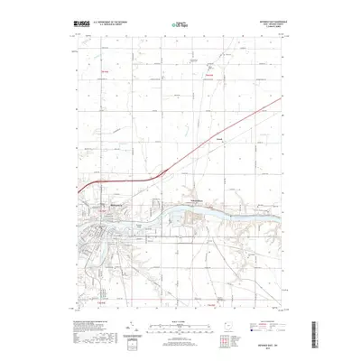
2019 Map of Defiance East
USGS Topo · Published 2019About this map
The confluence of the Maumee River and the Auglaize River anchor this 2019 survey of the area surrounding Defiance. The city center is densely detailed, featuring landmarks such as the Defiance County Courthouse and the campus of Defiance College. This landscape is defined by its deep agricultural and cemetery history, with numerous family and church burial grounds scattered across the township lines, including Saint Michaels Catholic Cem and Poplar Ridge Cem.
Find a feature on this map
127 named features on this map. Tap any name to fly to it.
Don’t see what you’re looking for? This feature index may not catch every label — zoom into the map to look around manually.
Map Details
Editions of this 2019 Defiance East Map
This is the sole edition of this map. No revisions or reprints were ever made.
Other maps of this area

1907 · Defiance
USGS Topo · 1:62,500

1908 · Ottawa
USGS Topo · 1:62,500

1908 · Napoleon
USGS Topo · 1:62,500

1909 · Defiance
USGS Topo · 1:62,500

1909 · Continental
USGS Topo · 1:62,500

1953 · Fort Wayne
USGS Topo · 1:250,000

1956 · Fort Wayne
USGS Topo · 1:250,000

1959 · Defiance East
USGS Topo · 1:24,000
1959 · Ridgeville Corners
USGS Topo · 1:24,000

1959 · Florida
USGS Topo · 1:24,000