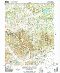
2000 Map of Defiance
USGS Topo · Published 2003About this map
Femme Osage Creek meanders toward the Missouri River in this detailed survey of southern St. Charles County at the turn of the millennium. The settlement of Defiance anchors the southeastern landscape, situated just above the floodplain of Darst Bottoms, while the village of Schluersburg sits tucked among the hills to the west. This period captures a landscape defined by significant conservation holdings, including the August A Busch Memorial State Conservation Area and Weldon Spring State Conservation Area, which dominate the eastern half of the map.
Find a feature on this map
33 named features on this map. Tap any name to fly to it.
Don’t see what you’re looking for? This feature index may not catch every label — zoom into the map to look around manually.
Map Details
Editions of this 2000 Defiance Map
This is the sole edition of this map. No revisions or reprints were ever made.
Other maps of this area

1903 · O'Fallon
USGS Topo · 1:125,000

1931 · Brussels
USGS Topo · 1:62,500

1937 · Weldon Spring
USGS Topo · 1:24,000

1939 · Brussels
USGS Topo · 1:62,500

1940 · Eureka
USGS Topo · 1:24,000

1940 · Weldon Spring
USGS Topo · 1:24,000

1941 · Troy
USGS Topo · 1:62,500

1943 · Brussels
USGS Topo · 1:62,500

1944 · Eureka
USGS Topo · 1:24,000

1945 · Troy
USGS Topo · 1:62,500