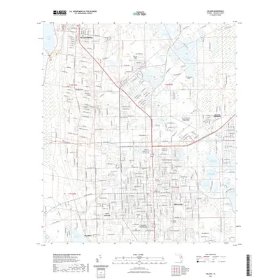
2021 Map of DeLand
USGS Topo · Published 2021About this map
DeLand and its surrounding communities are defined by a dense concentration of freshwater lakes and established institutional landmarks in this recent 2021 survey. The campus of Stetson University sits at the heart of the city, adjacent to the Volusia County Courthouse, while the surrounding residential areas expand into North DeLand, West DeLand, and DeLand Southwest. The landscape is dotted with numerous small bodies of water, including Painters Pond, Blue Lake, and the larger Spring Garden Lake to the northwest. This map provides a clear view of the region's transportation infrastructure, dominated by the CSX Transportation rail line and the DeLand Municipal Airport-Sidney H Taylor Field. Genealogists will find several burial grounds of interest, such as the Pentecostal Holiness Church Cem, Glenwood Cem, and DeLand Memorial Gardens, which reflect the long-standing community structure of Volusia County.
Find a feature on this map
197 named features on this map. Tap any name to fly to it.
Don’t see what you’re looking for? This feature index may not catch every label — zoom into the map to look around manually.
Map Details
Editions of this 2021 DeLand Map
This is the sole edition of this map. No revisions or reprints were ever made.
Other maps of this area

1954 · Daytona Beach
USGS Topo · 1:250,000

1955 · Orlando
USGS Topo · 1:250,000

1957 · Orlando
USGS Topo · 1:250,000

1958 · Orlando
USGS Topo · 1:250,000

1958 · Daytona Beach
USGS Topo · 1:250,000

1962 · Orlando
USGS Topo · 1:250,000

1962 · Pine Lakes
USGS Topo · 1:24,000

1962 · Daytona Beach NW
USGS Topo · 1:24,000

1962 · Daytona Beach SW
USGS Topo · 1:24,000

1962 · Lake Woodruff
USGS Topo · 1:24,000