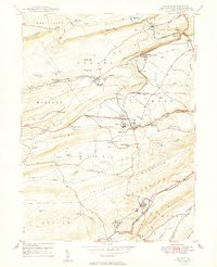
1949 Map of Delano
USGS Topo · Published 1949About this map
Industrial coal-country infrastructure and steep topography characterize the landscape of Schuylkill County in the late 1940s. The region is defined by the Reading and Central RR of Pennsylvania lines, which navigate the narrow gaps of Broad Mountain and Locust Mountain. Local industry is anchored by operations such as the Primrose Mine and the rail hub at East Mahanoy Jet. The map reveals a high density of rural social infrastructure, including several named schools like Lakeside Sch and Messerschmidt Sch, which served the scattered mining and railroad hamlets.
Find a feature on this map
77 named features on this map. Tap any name to fly to it.
Don’t see what you’re looking for? This feature index may not catch every label — zoom into the map to look around manually.
Map Details
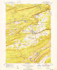
Editions of this 1949 Delano Map
2 editions found
Other maps of this area

1889 · Hazleton
USGS Topo · 1:62,500

1889 · Pottsville
USGS Topo · 1:62,500

1891 · Hazleton
USGS Topo · 1:62,500

1891 · Pottsville
USGS Topo · 1:62,500

1892 · Mahanoy
USGS Topo · 1:62,500

1893 · Hazleton
USGS Topo · 1:62,500

1893 · Mahanoy
USGS Topo · 1:62,500

1909 · Hamburg
USGS Topo · 1:62,500

1911 · Hamburg
USGS Topo · 1:62,500

1944 · Pottsville
USGS Topo · 1:24,000
Featured Places
- Hometown, Rush Township
- Delano, Delano Township
- Schuylkill Township, PA
- Haucks, Rush Township
- Buck Mountain, Mahanoy Township