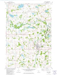
1981 Map of Delano
USGS Topo · Published 1982About this map
The confluence of the North Fork Crow River and the South Fork Crow River anchors this 1981 survey of the Wright and Hennepin county border. The city of Delano serves as the primary hub, where the Burlington Northern railroad corridor meets a cluster of civic and religious landmarks. For those researching local heritage, the map is remarkably dense with cemeteries, documenting sites like Mt Olive West Cem and Mt Olive East Cem, which suggest the historic expansion of local congregations. Outside the city center, the landscape is defined by glacial kettle lakes such as Dean Lake and Crawford Lake, alongside the developed recreation areas at Lake Rebecca County Park. This map records a period of established agricultural and residential patterns before the rapid suburbanization of the late twentieth century reached this portion of the Crow River valley.
Find a feature on this map
49 named features on this map. Tap any name to fly to it.
Don’t see what you’re looking for? This feature index may not catch every label — zoom into the map to look around manually.
Map Details
Editions of this 1981 Delano Map
This is the sole edition of this map. No revisions or reprints were ever made.
Other maps of this area

1905 · Minnetonka
USGS Topo · 1:62,500

1907 · Minnetonka
USGS Topo · 1:62,500

1909 · Rockford
USGS Topo · 1:62,500

1953 · Saint Paul
USGS Topo · 1:250,000

1953 · Stillwater
USGS Topo · 1:250,000

1955 · Stillwater
USGS Topo · 1:250,000

1957 · Waconia
USGS Topo · 1:62,500

1958 · Stillwater
USGS Topo · 1:250,000

1958 · Rockford
USGS Topo · 1:62,500

1958 · Mound
USGS Topo · 1:24,000