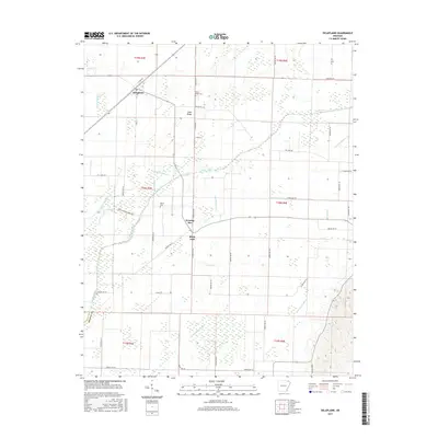
2017 Map of Delaplaine
USGS Topo · Published 2017About this map
Delaplaine serves as a focal point in this portion of Greene County, situated in a landscape heavily defined by an intricate network of drainage and irrigation. The naturally meandering course of the Cache River is supplemented by engineered waterways including the Main Canal, Swan Pond Ditch, and numerous numbered laterals like Lateral Number 7. This system indicates a highly managed agricultural environment, where the land has been meticulously shaped to control water across the flat terrain. Small settlements such as Evening Star, Black Jack, and Jones Ridge are scattered along the rural road grid, often linked by routes like Okean Evening Star Rd. Local history is preserved at the Bonds Cemetery and Jones Ridge Cemetery, which stand as quiet landmarks among the expansive fields and agricultural plots.
Find a feature on this map
58 named features on this map. Tap any name to fly to it.
Don’t see what you’re looking for? This feature index may not catch every label — zoom into the map to look around manually.
Map Details
Editions of this 2017 Delaplaine Map
This is the sole edition of this map. No revisions or reprints were ever made.
Other maps of this area

1932 · Walnut Ridge
USGS Topo · 1:62,500

1935 · Knobel
USGS Topo · 1:62,500

1935 · Reyno
USGS Topo · 1:62,500

1935 · Walnut Ridge
USGS Topo · 1:62,500

1940 · Gainesville
USGS Topo · 1:62,500

1941 · Knobel
USGS Topo · 1:62,500

1957 · Poplar Bluff
USGS Topo · 1:250,000

1958 · Gainesville
USGS Topo · 1:62,500

1959 · Poplar Bluff
USGS Topo · 1:250,000
1960 · Gainesville
USGS Topo · 1:62,500