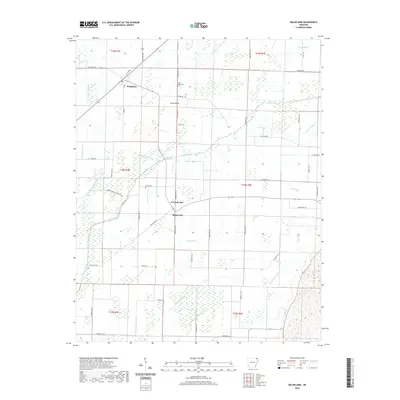
2020 Map of Delaplaine
USGS Topo · Published 2020About this map
Delaplaine sits at the junction of State Hwy 304 and State Hwy 280, serving as the primary hub in this corner of Greene County. The surrounding landscape is defined by an extensive network of water management, where the Cache River is supplemented by numerous engineered channels like the Main Canal and Swan Pond Ditch. These waterways, alongside numbered laterals such as Lateral Number 12 and Lateral Number 7, reflect a highly organized agricultural environment designed to drain the fertile lowlands. Small communities and named locales including Evening Star, Jones Ridge, and Black Jack are scattered throughout the township lines, often centered on local cemeteries like Jones Ridge Cem and Bonds Cem. The grid of county roads, including O'Kean Evening Starr Rd and N Cannon, provides a clear view of modern rural land division and settlement patterns in northeastern Arkansas.
Find a feature on this map
60 named features on this map. Tap any name to fly to it.
Don’t see what you’re looking for? This feature index may not catch every label — zoom into the map to look around manually.
Map Details
Editions of this 2020 Delaplaine Map
This is the sole edition of this map. No revisions or reprints were ever made.
Other maps of this area

1932 · Walnut Ridge
USGS Topo · 1:62,500

1935 · Knobel
USGS Topo · 1:62,500

1935 · Reyno
USGS Topo · 1:62,500

1935 · Walnut Ridge
USGS Topo · 1:62,500

1940 · Gainesville
USGS Topo · 1:62,500

1941 · Knobel
USGS Topo · 1:62,500

1957 · Poplar Bluff
USGS Topo · 1:250,000

1958 · Gainesville
USGS Topo · 1:62,500

1959 · Poplar Bluff
USGS Topo · 1:250,000
1960 · Gainesville
USGS Topo · 1:62,500