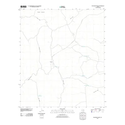
2010 Map of Delaware Ranch
USGS Topo · Published 2010About this map
Delaware Ranch serves as the central hub of this arid Culberson County landscape, where the foothills of the Delaware Mountains meet a complex network of canyons and seasonal drainages. Life in this corner of West Texas is dictated by the availability of water, as evidenced by the distribution of man-made and natural catchments such as Saint John Tank, Butterass Tank, and the naturally occurring Rock Water Hole. The terrain is deeply incised by prominent features like Maverick Canyon and Ed Ray Canyon, providing a detailed look at the geographic isolation of ranching life.
Find a feature on this map
16 named features on this map. Tap any name to fly to it.
Don’t see what you’re looking for? This feature index may not catch every label — zoom into the map to look around manually.
Map Details
Editions of this 2010 Delaware Ranch Map
This is the sole edition of this map. No revisions or reprints were ever made.
Other maps of this area

1906 · Van Horn
USGS Topo · 1:125,000

1928 · Kent
USGS Topo · 1:125,000

1954 · Van Horn
USGS Topo · 1:250,000

1958 · Van Horn
USGS Topo · 1:250,000

1972 · Seven Heart Gap
USGS Topo · 1:24,000

1972 · Square Mesa
USGS Topo · 1:24,000

1973 · K C Ranch
USGS Topo · 1:24,000
1973 · Dome Hill
USGS Topo · 1:24,000
1973 · Delaware Ranch
USGS Topo · 1:24,000

1973 · Burro Canyon
USGS Topo · 1:24,000