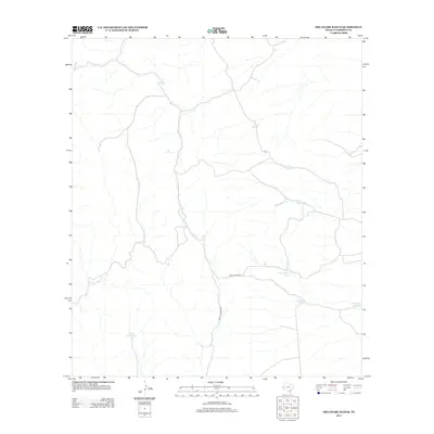
2013 Map of Delaware Ranch
USGS Topo · Published 2013About this map
Scott House Tank and a network of isolated water catchments define this arid landscape in Culberson County during the early 21st century. The terrain is largely dominated by ephemeral drainage patterns, where essential water sources for ranching are found at named locations like Cowan Tank, Saint John Tank, and Goat Tank. Transportation through this remote section of West Texas relies on unpaved routes, including Looney Spur Rd and Casa De Piedras Rd, which connect the scattered infrastructure. These features represent the continuing reliance on traditional water management in the Trans-Pecos region. Other landmarks such as Rock Water Hole, Butterass Tank, and Segunda Tank highlight the importance of specific collection points for livestock and land management in a high-desert environment.
Find a feature on this map
9 named features on this map. Tap any name to fly to it.
Don’t see what you’re looking for? This feature index may not catch every label — zoom into the map to look around manually.
Map Details
Editions of this 2013 Delaware Ranch Map
This is the sole edition of this map. No revisions or reprints were ever made.
Other maps of this area

1906 · Van Horn
USGS Topo · 1:125,000

1928 · Kent
USGS Topo · 1:125,000

1954 · Van Horn
USGS Topo · 1:250,000

1958 · Van Horn
USGS Topo · 1:250,000

1972 · Seven Heart Gap
USGS Topo · 1:24,000

1972 · Square Mesa
USGS Topo · 1:24,000

1973 · K C Ranch
USGS Topo · 1:24,000
1973 · Dome Hill
USGS Topo · 1:24,000
1973 · Delaware Ranch
USGS Topo · 1:24,000

1973 · Burro Canyon
USGS Topo · 1:24,000