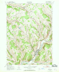
1943 Map of Delhi
USGS Topo · Published 1970About this map
The West Branch Delaware River and the Little Delaware River converge at the village of Delhi, which served as a regional hub for education and healthcare in the mid-1940s. The landscape is marked by prominent institutions such as the State Agricultural and Technical Institute and Delaware Academy and Central Sch, alongside the County Sanatorium located south of the main settlement. Transportation networks are deeply etched into the topography, featuring the route of the New York Ontario and Western railroad and historical thoroughfares like the Catskill Turnpike and Old Catskill Turnpike. To the north, the smaller settlement of Meridale sits along Ouleout Creek, while numerous numbered schoolhouses and cemeteries like Woodland Cem and Old Scotch Cem dot the hills and valleys of Meredith and Delhi townships.
Find a feature on this map
46 named features on this map. Tap any name to fly to it.
Don’t see what you’re looking for? This feature index may not catch every label — zoom into the map to look around manually.
Map Details
Editions of this 1943 Delhi Map
3 editions found
Other maps of this area

1909 · Delhi
USGS Topo · 1:62,500

1911 · Delhi
USGS Topo · 1:62,500

1915 · Oneonta
USGS Topo · 1:62,500

1918 · Oneonta
USGS Topo · 1:62,500

1922 · Andes
USGS Topo · 1:62,500

1923 · Walton
USGS Topo · 1:48,000

1924 · Andes
USGS Topo · 1:62,500

1925 · Walton
USGS Topo · 1:62,500

1943 · Delhi
USGS Topo · 1:24,000

1943 · Bloomville
USGS Topo · 1:24,000