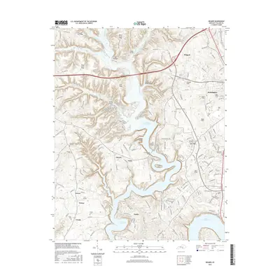
2016 Map of Delmer
USGS Topo · Published 2016About this map
Lake Cumberland dominates the southern half of this landscape, its winding shoreline and numerous inlets like Thompson Br and Fall Run defining the local geography. The map captures a mix of established communities and rural outposts, ranging from the outskirts of Somerset to smaller settlements such as Oil Center, Shepola, and Delmer. For genealogists and local historians, the sheet is dense with family-named landmarks and burial grounds, including the Zollicoffer Park Cem, Hill Baptist Church Cem, and the prominent Lakeside Memorial Gardens. Transportation is anchored by the Cumberland Pkwy, which cuts through the northern ridges. The terrain transitions from the high ground of Beech Grove Ridge and Piney Grove Ridge down to the water's edge, where Fishing Creek Bridge serves as a vital crossing point. Small airfields like Lee's Airpark and scattered rural churches like Pisgah Church illustrate the distributed nature of Pulaski County life in the mid-2010s.
Find a feature on this map
200 named features on this map. Tap any name to fly to it.
Don’t see what you’re looking for? This feature index may not catch every label — zoom into the map to look around manually.
Map Details
Editions of this 2016 Delmer Map
This is the sole edition of this map. No revisions or reprints were ever made.
Other maps of this area

1911 · Monticello
USGS Topo · 1:62,500

1914 · Monticello
USGS Topo · 1:62,500

1932 · Burnside
USGS Topo · 1:62,500

1935 · Somerset
USGS Topo · 1:62,500

1953 · Frazer
USGS Topo · 1:24,000

1953 · Mintonville
USGS Topo · 1:24,000

1953 · Mill Springs
USGS Topo · 1:24,000
1954 · Bobtown
USGS Topo · 1:24,000

1954 · Burnside
USGS Topo · 1:24,000

1954 · Delmer
USGS Topo · 1:24,000