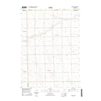
2015 Map of Delmont NE
USGS Topo · Published 2015About this map
Agricultural lands and intermittent drainage patterns define this corner of the Great Plains where the borders of Douglas, Davison, and Hutchinson counties meet. The landscape is structured by a precise mile-square grid of local roads, including 268th St and 407th Ave, which partition the prairie into large-scale farming tracts. Water management and natural topography are evident through the paths of the S Fork Twelvemile Cr in the north and Coffee Cr through the center, both meandering across the township lines. A significant historical landmark for genealogists is the Miller Cem, located in the southeastern quadrant, serving as a quiet marker of the families who settled this rural expanse. In the south, Pony Cr cuts through the terrain, illustrating the hydrologic network that supported early homesteads and modern agriculture alike.
Find a feature on this map
28 named features on this map. Tap any name to fly to it.
Don’t see what you’re looking for? This feature index may not catch every label — zoom into the map to look around manually.
Map Details
Editions of this 2015 Delmont NE Map
This is the sole edition of this map. No revisions or reprints were ever made.
Other maps of this area

1898 · Olivet
USGS Topo · 1:125,000

1899 · Mitchell
USGS Topo · 1:125,000

1899 · Alexandria
USGS Topo · 1:125,000

1955 · Sioux Falls
USGS Topo · 1:250,000

1955 · Mitchell
USGS Topo · 1:250,000

1957 · Ethan
USGS Topo · 1:24,000

1958 · Sioux Falls
USGS Topo · 1:250,000

1959 · Mitchell
USGS Topo · 1:250,000

1979 · Delmont
USGS Topo · 1:24,000
1979 · Delmont NE
USGS Topo · 1:24,000
Featured Places
- Washington Township, SD
- Rome Township, SD
- Tobin Township, SD
- Lincoln Township, SD
- Susquehanna Township, SD