
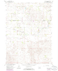
1963 Map of Deloit SW
USGS Topo · Published 1964About this map
St Anthonys Cem sits atop the undulating sandhills of northern Wheeler County, marking a localized pocket of settlement in the early 1960s. This survey, conducted as part of the Missouri River Basin development program, captures a landscape defined by its hydrology and township-grid boundaries. The Holt Co Wheeler Co line bisects the region, where drainage is dominated by the meandering path of Clearwater Creek and its associated seasonal wetlands. Education and community life are represented by the isolated School No 146, a classic marker of rural Nebraskan social organization before mid-century school consolidations reached their peak. The map illustrates a ranching-oriented economy where scattered wells provide the essential water needed to sustain life in the expansive Clearwater and Deloit precincts.
Find a feature on this map
10 named features on this map. Tap any name to fly to it.
Don’t see what you’re looking for? This feature index may not catch every label — zoom into the map to look around manually.
Map Details
Editions of this 1963 Deloit SW Map
2 editions found
Other maps of this area

1954 · Bartlett
USGS Topo · 1:24,000

1955 · Broken Bow
USGS Topo · 1:250,000

1955 · O'Neill
USGS Topo · 1:250,000

1956 · Broken Bow
USGS Topo · 1:250,000

1959 · O'Neill
USGS Topo · 1:250,000

1960 · Spalding 2 NW
USGS Topo · 1:24,000

1960 · Spalding 2 NE
USGS Topo · 1:24,000

1963 · Deloit
USGS Topo · 1:24,000

1963 · Deloit NE
USGS Topo · 1:24,000

1963 · Deloit NW
USGS Topo · 1:24,000