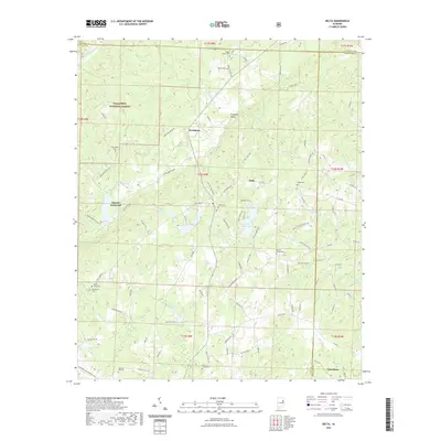
2021 Map of Delta
USGS Topo · Published 2021About this map
Delta and the surrounding rural communities of Clay and Cleburne counties sit at the intersection of a complex hydrological and mountainous landscape. This high-country region is defined by the headwaters of numerous creeks, including Ketchepedrakee Cr and Chulafinnee Cr, which carve through valleys like Fishhead Valley. The settlement pattern follows these ridges and stream beds, with small crossroads such as Needmore and Haynes Crossroad serving as local anchors. Portions of the Talladega National Forest cover the western slopes, underscoring the timber and wilderness character of the area. A high density of rural burial grounds, such as Shiloh Cem and Ragan Chapel Cem, points to a long-established community structure centered around family and church. Significant man-made water bodies including Lake Gerald and Upper State Lake indicate the importance of water management and recreation in this upland terrain.
Find a feature on this map
113 named features on this map. Tap any name to fly to it.
Don’t see what you’re looking for? This feature index may not catch every label — zoom into the map to look around manually.
Map Details
Editions of this 2021 Delta Map
This is the sole edition of this map. No revisions or reprints were ever made.
Other maps of this area

1891 · Ashland
USGS Topo · 1:125,000

1900 · Anniston
USGS Topo · 1:125,000

1947 · Oxford
USGS Topo · 1:24,000

1950 · Anniston
USGS Topo · 1:62,500

1953 · Atlanta
USGS Topo · 1:250,000

1956 · Oxford
USGS Topo · 1:24,000

1957 · Atlanta
USGS Topo · 1:250,000

1958 · Atlanta
USGS Topo · 1:250,000
1967 · Ross Mountain
USGS Topo · 1:24,000
1967 · Hollis Crossroads
USGS Topo · 1:24,000