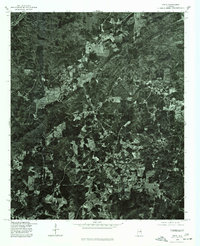
1975 Map of Delta
USGS Topo · Published 1977About this map
Delta serves as the central hub of this mid-1970s orthophotoquad, which uses aerial photography from November 1975 to document the rural character of Clay County. Unlike traditional topographic maps, this imagery reveals the exact texture of the landscape, from the cleared agricultural plots at Needmore to the heavily forested ridges surrounding Christiana. The transition between small-scale farming and dense timberland is visible in the varied canopy and road network, which winds through the terrain rather than following a rigid grid. Produced in cooperation with the Soil Conservation Service, the map provides an unvarnished view of land use and timber management in this part of Alabama during the late twentieth century.
Find a feature on this map
3 named features on this map. Tap any name to fly to it.
Don’t see what you’re looking for? This feature index may not catch every label — zoom into the map to look around manually.
Map Details
Editions of this 1975 Delta Map
This is the sole edition of this map. No revisions or reprints were ever made.
Other maps of this area

1891 · Ashland
USGS Topo · 1:125,000

1900 · Anniston
USGS Topo · 1:125,000

1947 · Oxford
USGS Topo · 1:24,000

1950 · Anniston
USGS Topo · 1:62,500

1953 · Atlanta
USGS Topo · 1:250,000

1956 · Oxford
USGS Topo · 1:24,000

1957 · Atlanta
USGS Topo · 1:250,000

1958 · Atlanta
USGS Topo · 1:250,000
1967 · Ross Mountain
USGS Topo · 1:24,000
1967 · Hollis Crossroads
USGS Topo · 1:24,000