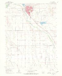
1962 Map of Delta
USGS Topo · Published 1978About this map
The confluence of the Gunnison River and Uncompahgre River anchors this early 1960s survey, highlighting the agricultural and transit infrastructure of Western Colorado. Irrigation is central to the landscape, with a vast network of laterals and canals serving California Mesa, Garnet Mesa, and Ash Mesa, all supported by the Garnet Mesa Reservoir. The city of Delta serves as the regional hub, showing a developed street grid including the Armory, High Sch, and a Hospital situated along the Denver and Rio Grande Western RR. Further south, the map documents rural life at Pea Green Corner and the Delta Co Montrose Co boundary, where local landmarks like Pea Green Cem, Columbine Sch, and the Ch of the First Born provide valuable reference points for genealogists and local historians.
Find a feature on this map
31 named features on this map. Tap any name to fly to it.
Don’t see what you’re looking for? This feature index may not catch every label — zoom into the map to look around manually.
Map Details
Editions of this 1962 Delta Map
3 editions found
Other maps of this area

1955 · Olathe NW
USGS Topo · 1:24,000

1955 · Olathe
USGS Topo · 1:24,000

1956 · Montrose
USGS Topo · 1:250,000

1956 · Moab
USGS Topo · 1:250,000

1959 · Moab
USGS Topo · 1:250,000

1959 · Montrose
USGS Topo · 1:250,000

1960 · Montrose
USGS Topo · 1:250,000

1960 · Moab
USGS Topo · 1:250,000

1962 · Moab
USGS Topo · 1:250,000
1962 · North Delta
USGS Topo · 1:24,000