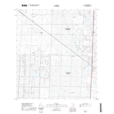
2021 Map of Delta
USGS Topo · Published 2021About this map
Loxahatchee Slough dominates the central landscape of this Florida quadrangle, representing a critical wetland corridor between the expanding urban footprints of Palm Beach Gardens and West Palm Beach. This survey captures the intersection of conservation and modernization, where the Loxahatchee Slough Natural Area Trl and Nena Trl provide access through preserved marshlands just miles from residential developments. The area's water management is visible through the engineering of the M Canal and Loxahatchee Canal, which historically served to drain and redirect water across the peninsula. Aviation infrastructure is centered at the North Palm Beach County General Aviation airport, situated near the settlement of Delta. The eastern portion of the map is defined by intricate residential networks, featuring roads like Ryder Cup Blvd and PGA Blvd, reflecting the region's mid-to-late 20th-century growth.
Find a feature on this map
158 named features on this map. Tap any name to fly to it.
Don’t see what you’re looking for? This feature index may not catch every label — zoom into the map to look around manually.
Map Details
Editions of this 2021 Delta Map
This is the sole edition of this map. No revisions or reprints were ever made.
Other maps of this area

1945 · Delta
USGS Topo · 1:24,000

1946 · Riviera Beach
USGS Topo · 1:24,000

1946 · Palm Beach Farms
USGS Topo · 1:24,000

1946 · Palm Beach
USGS Topo · 1:24,000

1948 · Rood
USGS Topo · 1:24,000

1948 · Jupiter
USGS Topo · 1:24,000

1949 · Rood
USGS Topo · 1:24,000

1949 · Palm Beach Farms
USGS Topo · 1:24,000

1949 · Riviera Beach
USGS Topo · 1:24,000

1950 · Jupiter
USGS Topo · 1:24,000