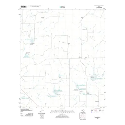
2010 Map of Democrat
USGS Topo · Published 2010About this map
The small settlement of Democrat serves as the focal point for this rural Mills County landscape, where the terrain is defined by distinct limestone uplifts and a complex network of water management features. Prominent heights like Turkey Peak Mountain and Long Pompey Mountain rise above the drainage basins of the South Leon River and Pompey Creek. This 2010 survey illustrates a region heavily shaped by the Blanket Creek Watershed project, including numerous numbered reservoirs such as Soil Conservation Service Site 19 Reservoir and Soil Conservation Service Site 15 Reservoir. These structures, along with Meyer Lake and Aldridge Lake, indicate a landscape modified for erosion control and water storage. Local history is anchored by the presence of the Democrat Cemetery and Dudley Cemetery, which remain key landmarks for genealogists alongside the transit corridors of FM 218 and FM 573.
Find a feature on this map
62 named features on this map. Tap any name to fly to it.
Don’t see what you’re looking for? This feature index may not catch every label — zoom into the map to look around manually.
Map Details
Editions of this 2010 Democrat Map
This is the sole edition of this map. No revisions or reprints were ever made.
Other maps of this area

1889 · Brownwood
USGS Topo · 1:125,000

1894 · Brownwood
USGS Topo · 1:125,000

1925 · Brownwood 3-d
USGS Topo · 1:48,000

1925 · Brownwood 4-c
USGS Topo · 1:48,000

1928 · Zephyr
USGS Topo · 1:62,500

1931 · Mullin
USGS Topo · 1:62,500

1950 · Zephyr
USGS Topo · 1:62,500

1950 · Mullin
USGS Topo · 1:62,500

1954 · Brownwood
USGS Topo · 1:250,000
1966 · Blanket
USGS Topo · 1:24,000