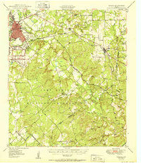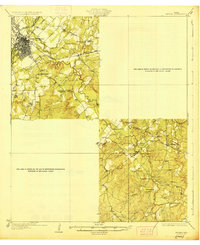
1928 Map of Zephyr
USGS Topo · Published 1928About this map
Brownwood serves as the bustling hub of this Central Texas landscape, where the Ft. Worth and Rio Grande and Santa Fe railroads converge near the banks of Pecan Bayou. The map reveals a deeply settled rural society defined by its local institutions, with numerous country schools like Delaware School and Slighdale School serving dispersed farmsteads. To the southeast, the terrain transitions into the creek-carved hills of the Brown Co Mills Co border region, where family names and community landmarks take center stage.
Find a feature on this map
37 named features on this map. Tap any name to fly to it.
Don’t see what you’re looking for? This feature index may not catch every label — zoom into the map to look around manually.
Map Details
Editions of this 1928 Zephyr Map
This is the sole edition of this map. No revisions or reprints were ever made.
Historical Maps of Brownwood Through Time
8 maps found