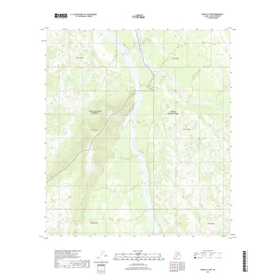
2017 Map of Denali B-4 NW
USGS Topo · Published 2017About this map
The Foraker River cuts through the heart of this Alaskan landscape, defining the boundary between two significant federal conservation areas. To the west lies the Denali National Preserve, while the eastern portion of the terrain is protected as part of Denali National Park. The topography is shaped by a network of drainage systems including Birch Creek, Hult Cr, and White Cr, which feed into the primary river corridor. This survey illustrates the intricate braided nature of the Foraker River, showing how its seasonal flow patterns have carved out a wide gravel bed. The absence of human-made infrastructure like roads or settlements underscores the wilderness character of the Denali Borough, where the natural hydrology and the official park boundaries are the primary features of the land.
Find a feature on this map
49 named features on this map. Tap any name to fly to it.
Don’t see what you’re looking for? This feature index may not catch every label — zoom into the map to look around manually.
Map Details
Editions of this 2017 Denali B-4 NW Map
This is the sole edition of this map. No revisions or reprints were ever made.
Other maps of this area

1952 · Mount McKinley
USGS Topo · 1:250,000

1953 · Mount McKinley C-5
USGS Topo · 1:63,360

1953 · Mount McKinley B-4
USGS Topo · 1:63,360

1953 · Mount McKinley B-5
USGS Topo · 1:63,360

1953 · Mount McKinley C-4
USGS Topo · 1:63,360

1954 · Mount McKinley C-4
USGS Topo · 1:63,360

1954 · Mount McKinley B-5
USGS Topo · 1:63,360

1954 · Mount McKinley C-5
USGS Topo · 1:63,360

1958 · Mount McKinley
USGS Topo · 1:250,000

1969 · Mount McKinley
USGS Topo · 1:250,000