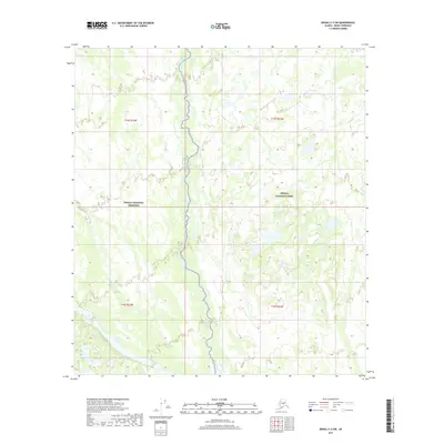
2017 Map of Denali C-4 SW
USGS Topo · Published 2017About this map
Birch Creek meanders through the central corridor of this wilderness region, marking a significant hydrological feature in the northern interior. The landscape is defined by the transition between protected lands, as the map illustrates the boundary where the Denali National Preserve meets the western edge of Denali National Park. In the southwestern corner, the Foraker River cuts through the terrain, further emphasizing the river-dominated geography of this subarctic environment. The absence of roads or permanent settlements in this 2017 survey reflects the remote, undisturbed character of the Denali Borough interior, where natural watercourses serve as the primary landmarks across the township and range divisions of T15S R23W and T16S R23W.
Find a feature on this map
8 named features on this map. Tap any name to fly to it.
Don’t see what you’re looking for? This feature index may not catch every label — zoom into the map to look around manually.
Map Details
Editions of this 2017 Denali C-4 SW Map
This is the sole edition of this map. No revisions or reprints were ever made.
Other maps of this area

1952 · Mount McKinley
USGS Topo · 1:250,000

1953 · Mount McKinley C-5
USGS Topo · 1:63,360

1953 · Mount McKinley B-4
USGS Topo · 1:63,360

1953 · Mount McKinley B-5
USGS Topo · 1:63,360

1953 · Mount McKinley C-4
USGS Topo · 1:63,360

1954 · Mount McKinley C-4
USGS Topo · 1:63,360

1954 · Mount McKinley B-5
USGS Topo · 1:63,360

1954 · Mount McKinley C-5
USGS Topo · 1:63,360

1958 · Mount McKinley
USGS Topo · 1:250,000

1969 · Mount McKinley
USGS Topo · 1:250,000