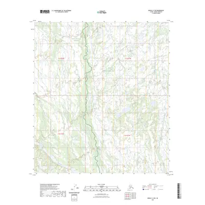
2023 Map of Denali C-4 SW
USGS Topo · Published 2023About this map
Denali National Park and the Denali National Preserve dominate this high-latitude terrain, where the boundary between park and preserve status splits the wilderness landscape. The northern reaches of the Foraker River flow through the southern section of the quadrangle, joined by the winding course of Birch Creek as it meanders through a dense network of smaller unnamed tributaries and wetlands. The map provides a precise layout of the Public Land Survey System grid, including townships t15s r23w and t16s r22w, illustrating how these administrative lines impose structure upon a vast, roadless subarctic environment. This 2023 edition documents the hydrography and glacial drainage patterns of the interior before any modern infrastructure has altered the natural flow of these vital Alaskan waterways.
Find a feature on this map
8 named features on this map. Tap any name to fly to it.
Don’t see what you’re looking for? This feature index may not catch every label — zoom into the map to look around manually.
Map Details
Editions of this 2023 Denali C-4 SW Map
This is the sole edition of this map. No revisions or reprints were ever made.
Other maps of this area

1952 · Mount McKinley
USGS Topo · 1:250,000

1953 · Mount McKinley C-5
USGS Topo · 1:63,360

1953 · Mount McKinley B-4
USGS Topo · 1:63,360

1953 · Mount McKinley B-5
USGS Topo · 1:63,360

1953 · Mount McKinley C-4
USGS Topo · 1:63,360

1954 · Mount McKinley C-4
USGS Topo · 1:63,360

1954 · Mount McKinley B-5
USGS Topo · 1:63,360

1954 · Mount McKinley C-5
USGS Topo · 1:63,360

1958 · Mount McKinley
USGS Topo · 1:250,000

1969 · Mount McKinley
USGS Topo · 1:250,000